The Rim to Rim to Rim [R3] run is a challenge for several reasons. First, it is long. The listed distance is anywhere between 44 and 50 miles. Second, is elevation. The South Rim is at 7200 ft, the lowest point, the Colorado River, is at 2500 ft and the North Rim is at 8240 ft. Third, the event is relatively unsupported, so you must carry whatever you want to eat, etc. with you. And finally, the weather. The day before we did it this year, the temperature at the South Rim was 33 degrees and at the same time it was 97 down at Phantom Ranch at the bottom by the river. All these elements make the course not only a physical challenge, but a logistical one also. Training for all these elements was a fun puzzle. This year, 2021, the puzzle had to be assembled while practicing social distancing since we could not use the normal race schedule to infuse and supplement our training.
The first piece of the puzzle is distance. While I had done the R3 when I was MUCH younger (four years ago when I was 68), Susan had never even entered a 5K. Susan, BTW, is 15 years younger than I am but very strong and determined. We started slowly to build up strength and endurance. Because I have been working on the Mount Wilson Trail a lot, at the beginning we alternated between the MWT and Bonelli Park. We went out every Sunday at 5:30 am and tried to do a little more each week. Speed was not a consideration, just endurance. After a few trips to the top of Mt. Wilson from Sierra Madre, we moved over to the backside by starting at Lake Ave. Eventually we were going to the top of Mt. Wilson by way of Mt. Disappointment and Mt. Lowe and the Mueller Tunnel. Eventually, we were up to 35 miles of hiking to the observatory and back by adding every conceivable detour to our route. From there we added one organized race, the Grandmaster Ultra 50 miler and then a training run on the Catalina 50-mile course. Once we felt good about our endurance, we made sure we added lots of elevation.
Since R3 has so much elevation change, over 11,000 feet, we had to do a lot of climbing. We used The Mount Wilson Trail, Bailey Canyon Trail, Catalina, and any other trail with big elevation changes we could find. We alternated between a hard climbing weekend and a flatter distance weekend. Because we had a whole year, we could go slowly. One result that I am most proud of is that neither of us sustained any injury, ever. One weekend we went to the Grand Canyon just to go from the South Rim down to Phantom Ranch on the South Kaibab Trail and back on the Bright Angel Trail, a mere 22 miles. I wanted to do it because we would be doing that section in the dark and I wanted Susan to see and experience that brutal climb in the daylight PLUS I wanted her to build her climbing legs. As Bill Dicky says, “That’s the toughest 5K in the world, you go up 1000 feet in every mile”.
The third part of the puzzle is the part about doing the event unsupported. Once you leave the South Rim of the Grand Canyon, you are on your own. Phantom Ranch can provide some support, but during Covid, everything there was done during limited hours through a window. We were able to reserve two “Hiker Lunches” and pick them up at 5:30am. In retrospect, they were not really needed. We did eat a few of the 4 things out of the sack, like the bagel, but not much else. We carried boiled potato cubes with salt, peanut butter and honey sandwiches, GU, and 70 oz of water. I carried 25oz of defrizzed Coke and Susan carried Gatorade powder. I had a small first aid kit, a Leatherman tool, wipes, hydrocortisone cream, and a few other items to save the event. We both had Pezel NAO+ headlamps (with an extra battery) and poles with bike gloves. We were wearing Hoka Speed Goats, compression socks and Dirty Girl gators. All these elements had been tried and refined on our training runs so there would be no surprises. The one element that we had to figure out when we got to the Grand Canyon was where there would be water. Fun Fact: all the water at the South Rim comes from the North Rim, which is much higher. The pipe runs under the trail we were on and it feeds some of the campsites on its way. In the winter months the Forest Service turns off some spigots so you must check with the Backcountry Office to find out where you can get fresh water. During our hike, the water was turned on at Indian Gardens, Phantom Ranch and Manzanita. None of these were more than 10 miles apart so I knew we could set out with 70oz of water and refill at every open spigot. One great part of this trip was that there was lots of snow at the North Rim. When we got there, we filled our Camelbacks with clean snow. It was GREAT. The water was cool and sweet almost all the way back down to the Colorado.
The last piece of the puzzle was the weather. There can easily be a 60-to-70-degree temperature change from the top of the canyon to the bottom. Because the bottom of the canyon can get so hot the best time to do this run is in April/May and September/October. To dodge the heat, we started on the South Kaibab Trail at 1am. My wife and brother-in-law drove us to the trail head to see us off. We went down the trail in the dark and crossed the Colorado on the Black Bridge a little after first light. Because we were at the bottom of a canyon, there were very few stars and no moon. You can only see about 15% of the sky from the bottom. The good news is that you are also out of the direct sunlight for almost 75% of your trip to the North Rim on the North Kaibab Trail. While we purchased micro spikes for our shoes, we did not need them because there was no ice on the trail at the North Rim. One of the valuable tools we used was the R3 Facebook page. We got great updates on trail and weather conditions from recent travelers. There are LOTS of people doing this run; we saw two serious runners pass us during our trek. Fun Fact: It is so popular that you can go on the Hiker Medal web site and buy an R3 medal; I got one for Susan. On the way back, the sun was setting so that we beat the heat then as well. The seriously tough part was the climb back up to the South Rim on the Bright Angel Trail from Phantom Ranch. We chose the Bright Angel Trail because it is not as steep and technical as the trail we came down, the South Kaibab Trail. The breeze coming down the canyon was like walking into a hair dryer even at 9pm. The air was so dry I went through almost all my 70oz of water in the 5 miles between Phantom Ranch and Indian Gardens. At both locations I both filled my Camelback and soaked my head from the spigot. At the many stream crossings coming down from Indian Gardens I put both my hat and buff in the water. The wind got colder as we hiked out of Indian Gardens, so we were slowly putting back on all the layers we took off coming down. A great windbreaker is essential for this trip.
We topped out at 5am, 28 hours after we started with a total of 58 miles on our Coros GPS watches. We probably picked up some extra miles at the North Rim walking around. The good news is that while 90% of the canyon is void of cell service, the North Rim has excellent cell service even when the rim is closed to visitors during the winter. There is one small section at the bottom near Ribbon Falls where you have a line of sight to the South Rim where text messages will get through. We had to include the time in our text messages because there was a lag in the service. Some messages went through immediately, others took hours.
We saw lots of wildlife on the hike. When we had our headlamps on, they attracted lots of flying insects. They, in turn, attracted lots of bats so we were constantly bombarded by bats flying into our field of vision. There are mule deer and white tail deer in the canyon so during the day they are next to the trail and at night your headlamp picks up lots of eyes looking out from the brush. On the trail there were small scorpions and centipedes that seemed to glow in the dark. The Bright Angel Creek flows next to the trail almost all the way to the North Rim. When you get to the North Rim it is truly spectacular because of the water and trees; much, much different than the dryer South Rim.
In total, a great adventure that challenges both strength, endurance, and planning. With training, I believe that any endurance runner could accomplish it. If you look on You Tube, there are movies of someone doing it in 6 hours, so youth and speed will make it go faster. I am happy with our accomplishment. Susan wants to do it again!
Click on map and photos to enlarge.
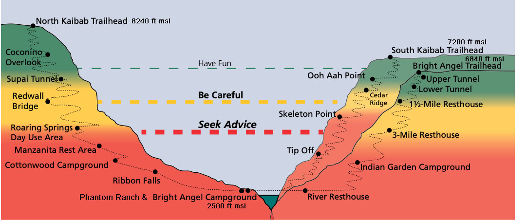
Elevation map taken from the National Park Service "Hike Into Grand Canyon" Brochure. This brochure has lots of good info on the trails.
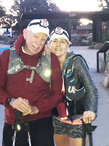
Bob Spears and Susan Mateer.
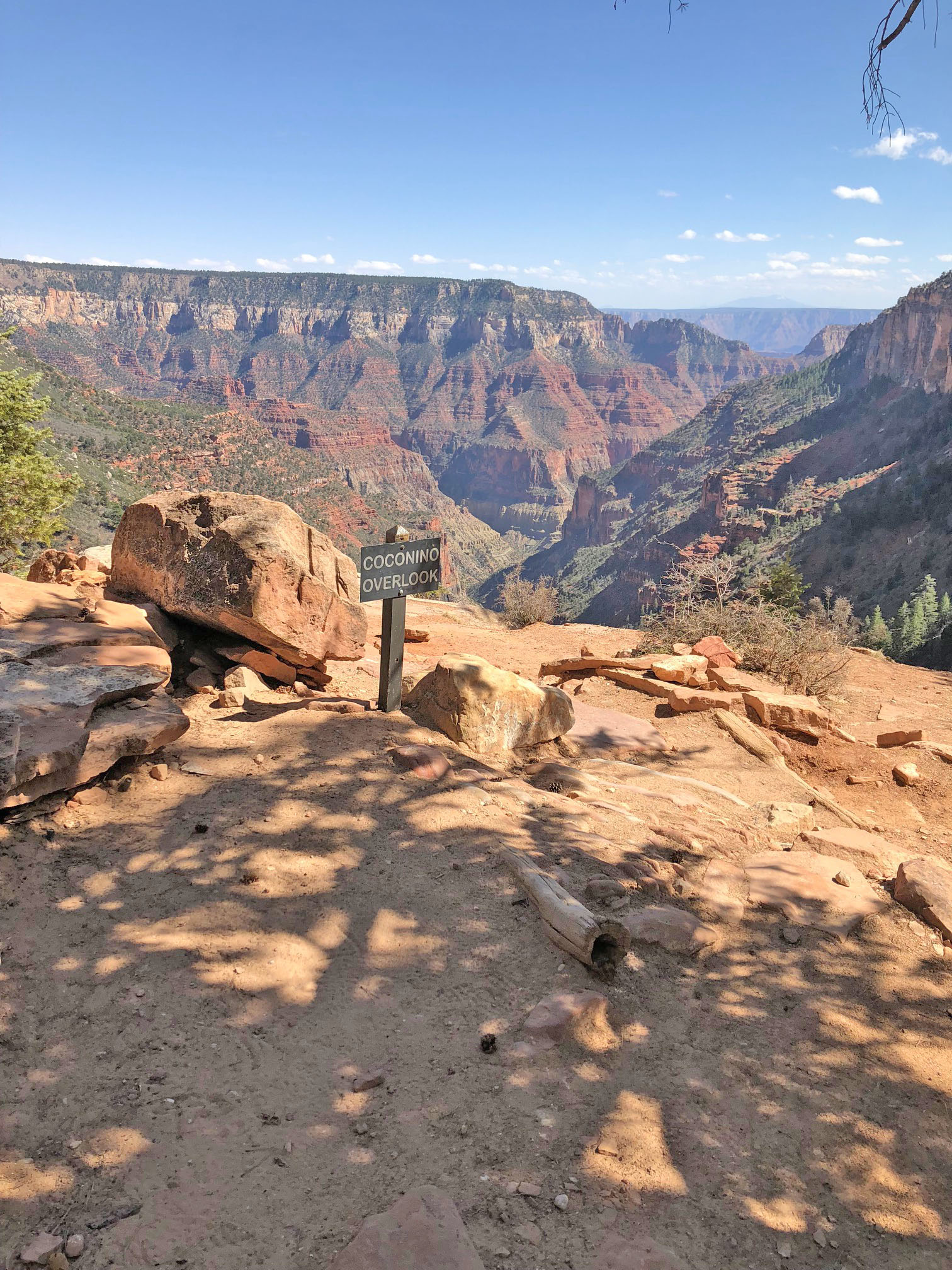
Coconino Overlook on the North Rim.
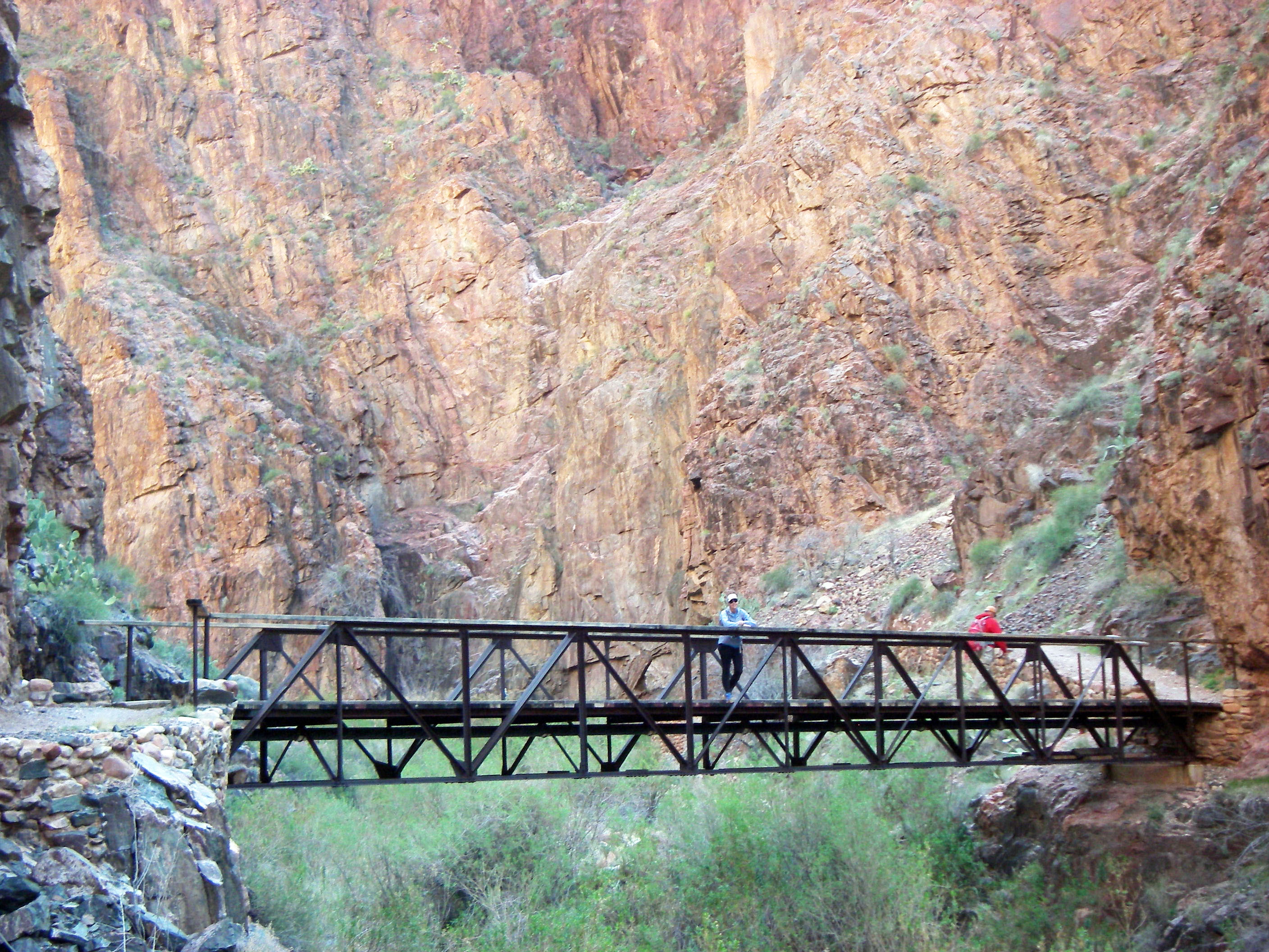
Susan crossing a bridge across Bright Angel Creek on the North Kaibob Trail.
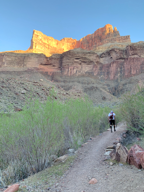
Bob starting up the North Kaibob trail toward the North Rim from Phantom Ranch a little after sunrise.
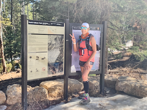
Susan, still smiling at the North Kaibab Trailhead.