Wednesday Night Fun Runs:
Click on the run names below for map and info.

Arboretum Loop - Flat 3.2 to 6.8 miles, Route sheet.
Long, Medium, Short and Walkers.
Count the peacocks.
Walkers Far Side alternative route/map.
Hillcrest - Hilly 4.2 to 7.3 miles - Route sheet pdf - mobile.
New optional routes including Todors Extra Credit hill loop,
Tanya's less traffic return, Nancy's Alleys
Walkers Far Side alternative route/map.
Mary's Market - Hilly 4.0 to 7.1 miles.
Walker, Runner, Climb and Chuck's Extra Credit routes or Mountain Trail.
What is Mary's Market
On a Wednesday night in the last half of December, this route will be inserted to see
the Sierra Madre Rose Parade float construction in the barn in the NW corner of
Sierra Vista Park.
If Wednesday falls on Oct. 31st we do the
Mountain Trail Pumpkin Patch.
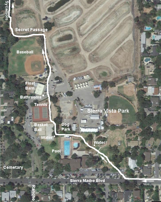
Detail through Sierra Vista Park with Secret Passage.
Walkers Far Side Climb alternative route/map - Route photos.
Singing Wood - Moderate rise 3.7 to 7.1 miles - Route sheet pdf, mobile
See the most expensive homes in Arcadia.
Walkers Map & Route sheet pdf, mobile
Walkers Far Side alternative route/map.
Yoshi's Run - Hilly 4.4 to 6.0 miles - mobile
First Wednesday of each month,
Best aid station anywhere.
Walkers Pace/Distance Map.
Walkers Far Side Climb alternative route/map.
Seasonal Wednesday Night Fun Runs:
Bruckners Loop - Flat 2.8 to 6.6 miles.
April to September months only, horse trail avoided due to homeless encampments.
Special Club Events:
A Snail's Pace - has loops from the running shop at 750 S. Myrtle Ave (NE corner with Walnut) Monrovia:
Pub Run - Trucker Tuesday Run - Hug-A-Huggins Run
These runs are substituted for a regular Wednesday night run when they invite us for a special event.
Clamshell Truck Trail run -
8am, December 24th, Christmas Eve Morning - a club tradition since 1982. Nice scenic out and back 8 mile round trip, with options, on a dirt road trail in the hills above Monrovia. Park before 7:40am to walk up Ridgeside 4/10 of a mile for the group photo at 7:55am sharp at the trail head driveway. Optional brunch after about 10:30am.
If Clamshell is used as an alternative to one of the last Wednesday of the month trail runs, the route is out to the Lookout and back - 4 miles RT.
Hastings Christmas Lights run - printable map and route sheet, mobile route sheet. Bill and Stella Dietrich started this sight seeing run in 1981 and the club has been doing it ever since on the 2nd or 3rd Wednesday in December. The walker and runner route map is updated for the current best streets a few days after the lights and decorations are all up and running by the 2nd Saturday in December. Walkers off at 6:00pm and runners at 6:10pm so to arrive at the Regroup location (see map and route sheet) about the same time. Wear Santa hats, antlers, lights, or costume on the run if you like. The club's Christmas party follows the run at 7:30pm.
Rose Parade Float run - Park on San Rafael Ave and walk up to the west end of the Colorado Blvd (Suicide) Bridge at Linda Vista, ready to go at 6:00 AM the morning of the Rose Parade in Pasadena. Walk or jog the route then meet back on the bridge to watch the flyover at 8 AM. Breakfast after at the Nano Cafe in Sierra Madre at 8:30am.
Run With Us - Up to 6 mile round trip out and back from the running store at 235 N. Lake Ave in Pasadena. This run is substituted for a regular Wednesday night run when they invite us for a special event.
Cool Breeze Bike Ride, 50K / 100K and more, 3rd Saturday in August, Ventura CA. Easy ride along the coast toward Santa Barbara. Great food aid stations and popsicles.
Ride for the Buns Bike Rides, Balboa (36.6 miles), Seal Beach (48 or 61 miles) with a cinnamon bun factory turn around.
Mountain Trail Maps:
On the last Wednesday of the months of April through September, the club runs the trails in the local mountains and each brings a picnic dinner for after. Occasionally, road closures due to slides or high fire danger have made us use alternate locations out of sequence. The locations will be announced in the monthly newsletter and by the weekly email. Those who do not know these trails or have not run trails before, need to run with those that have for safety. Good trail running shoes or street shoes with a good ground gripping tread are a must. Carrying a single water bottle pack and flash light are suggested. Also it is a good idea to carry a FRS walkie talkie on channel 14 in case you or some one near you gets lost or injured.
See the interesting descriptions and history of the Sierra Madre trails.
Are you a real Trail Runner? Take this test.
Altadena Crest Trail - this trail goes along the base of the mountains from Eaton Canyon to Loma Alta Park with a break on each side of Fair Oaks Ave. Part of this trail from the Tenoble to Zane Gray trailheads is an alternative to our Echo Mountain Wednesday night trail run - Runner route map Walker route map.
Bailey Canyon Trail - from Bailey Canyon Park, 451 W. Carter in Sierra Madre. Starting at 6:15pm, go up the trail until 7:10 PM or til you reach the ruins at 2.2 miles then turn around. Faster runners might reach Jones Peak at 3.3 miles for a great view. There are 3 sets of benches where you can take a break and take in the great views.
Cloverleaf/HairpinLoop - 2 mile scenic trail in the Monrovia Hillside Wilderness Preserve.
Echo Mountain and the cable car ruins - The trail head is at the top of Lake Ave in Altadena. Round trip is about 5.5 miles. Check out the photo's at the top of what the cable car, hotel, zoo, observatory, etc., looked like over 100 years ago. See the video history of the Mt. Lowe Railway.
If the Echo trail is closed on a last Wednesday run we meet at Dan at Lori's house and do a loop that contains part of the Altadena Crest trail. Walker route is a 3.4/4.0 mile loop and runners a 5 mile loop.
Flint Canyon - Start from the turn around at the south end of the parking road that paralles the fence and Oak Grove Dr. in Hahamongna Park. This is an interesting trail following a stream at the base of the Flintridge hills. One way distance is about 2 miles but can be extended into the Cherry Canyon maze of trails.
Gabrielino Western Trail run is an out and back up the Arroyo Seco in Pasadena from the JPL eastern parking lot and turn around at the Brown Canyon Debris Dam/ Paul Little Camp Ground for 8.5 miles round trip. For a shorter distances you can turn around at the Gould Mesa trail junction for 4.2 miles round trip.
Hoegee's Loop - Starting from Chantry Flat, the just under 6 mile loop goes clockwise (all right turns at every trail junction) out the Upper Winter Creek trail to Hoegee's Camp and back via the Lower Winter Creek trail.
Microwave Site out and back from the Chantry Flats upper parking lot. Bring a flashlight for the return depending on sunset.. The gate at the top of Santa Anita is locked by the Sierra Madre PD at 8PM, so leave the parking lot in a group with some one that has a key.
Monrovia Falls out and back from Grand Ave Park to the falls in Monrovia Canyon Park is 5.4 miles via the Bill Cull Trail. Shorter via picking up the falls trail from the Picnic parking lot, or doing the Overlook Trail - see map detail.
Monrovia Hillside Wilderness Preserve - There are a number of trails in the foothills above Monrovia.
Cloverleaf/Hairpin Loop - 1.7 mile loop exploring some of the single tracks in the Wilderness Preserve. If you want a little more, when you get back to the Ranger Station, take Roberts Crazy 8 Trail for 9/10ths more.
Clamshell trail traverses the upper part of the Preserve from Ridgeside on the East to Wilderness Park on the West or Cloverleaf and Highland on the South. Out and back about 8 miles.
Highland/Cloverleaf Loop map - This is a short - 1.83 miles - but hilly climb trail loop taken from the Cloverleaf side of the Monrovia Wilderness Preserve and uses the Lower Clamshell Connector Trail.
Mount Wilson Trail in Sierra Madre. Start at Mt. Wilson Trail Park, 189 E. Mira Monte - take Baldwin Ave north from the 210 almost all the way up and turn right on Mira Monte. Most can make the 1.5 Miles to First Water before the 7:00pm turn around time and then come back down. As an alternative, there is a new bypass trail you can take by turning left at the top of the Slide Switchbacks. Charlies New Trail comes back down to the Mt. Wilson Trail at Rescue Ridge and has great views from the benches - See the Slide Bypass Map. If you take the Mt. Wilson Trail all the way up to Mt. Wilson, it is about 7 miles. Also check out the Mt. Wilson Trail race review.
Sierra Vista Park Run. Substitute last Wednesday night trail run when mountain trails are closed or used when going to Mary's Market for breakfast. Walkers use the Far Side route Map and Route Photos.
Sturtevant Falls run from Chantry Flat, it is a keyhole out and back of about 5 miles going out on the Lower trail and coming back on the upper trail from the Fern Lodge Junction. Walkers can go 3 miles round trip to the base of the falls.
Other trail maps in the local area:
7th Ave Trail -This trail in Hacienda Heights is a good alternative to Chantry Flat if Chantry is closed due to high fire danger or road closings. The 2.7 mile run is a loop that goes up to the Skyline/Schabarum trail and back with a 660ft altitude gain and can be extended either direction on top on the old Skyline Trail which goes from the 605 to the 57. It is a good training area for those doing the Catalina Marathon or Avalon 50M/50K. The Skyline trail basically follows the Edison high tension power lines across the top of the Puente Hills - see maps and info. Trails are open from 9am to 5pm.
Arroyo Seco Trails - Popular, relatively flat urban trail system on the west side of Pasadena.
Azusa Canyon, West Fork - This used to be a club run the Friday morning after Thanksgiving and was called the "Turkey
Burner" where we would work some calories off run/walk/riding up the West Fork of the San Gabriel River in Azusa Canyon. Out and back on paved no vehicle road next to a stream. Gentle rise to the 6 mile marker then 400 ft climb to Cogswell Dam.
When the West Fork is closed due to fire or other, the East Fork is the alternate. This area has the Bridge to Nowhere and the Road to Nowhere.
Bonelli Park Trails - This 2000 acre LA County park surrounding Puddingstone Reservour in San Dimas has miles of single track trails.
Brown Mountain Loops - from the end of Altadena Dr. in Altadena you can access trails that use the Arroyo by JPL as the starting point.
Cherry Canyon Trails - A complex of trails just south of the 210 and east of the 2 in La Canada - Flintridge.
Dawn Mine Loop - A 10 mile round trip trail run to an old gold mine in the mountains above Altadena. It is an adventure back in to the history of 100 years ago.
Eaton Canyon Falls - from the Eaton Canyon Nature Center - run/hike to the falls, just under 2 miles. After the initial stream crossing at the start, follow the trail on the east side of the stream. Just after the bridge, there will be 10 stream crossings in a half mile to the falls. Bring a change of shoes. An alternative is to go up to Henninger Flat with only one stream crossing at the start - see hiking trails
El Prieto & Gabrielino Western Trail - Round trip from the Gabrielino Western Trailhead in Altadena to the Brown Mountain Road on the El Prieto Trail is 5.8 miles. This trail is the last single track section of the AC100.
Glendora South Hills Park - This close by and easy access Park has an interesting maze of single track trails right next to the 210 Freeway. In the north part of Glendora there are a series of trails off of Glendora Mountain Road and Big Dalton Canyon.
Griffith Park Hozers Loop - Good hilly long training run for marathon or ultra with 4 water stops. Plenty of cross trails to make it shorter or longer. There is a 3.5 mile tour of Hozer's Benches you can take from the Bird Sancturary.
Hastings Peak Loop - Tough 11.7 mile loop from Bailey Canyon Park in Sierra Madre to the Mt. Wilson Toll Road and back down Mt. Wilson Trail from Manzantia Ridge. Or add a scenic 2 mile out and back to the Bailey Canyon run.
Henninger Flat - from the Eaton Canyon Nature Center - run/hike to the Flats, just under 3 miles. After the initial stream crossing at the start, follow the trail on the east side of the stream. About .4 miles up the canyon, turn right at the sign,
Millard Loop - 6.6 mile loop from the west end of Altadena Dr going up the Altadena Crest Trail from Loma Alta Park to Millard Campground. Then along the Lower Brown Mountain road to take the El Prieto trail down to the Gabrielino Trail and back to the end of Altadena Dr.
Monrovia Canyon - A 7 to 9.5 mile round trip, 2000ft rise trail run to see the Deer Park Lodge ruins and the historic Ben Overturff trail.
Mt. Baden-Powell - Nice trail and part of the AC100 course from Vincent Gap up and back or continue on to Islip Saddle.
Mt. Lowe Trail - 16 mile round trip from the top of Lake St. in Pasadena via the Sam Merrill trail going up the East Mt. Lowe trail to the top and coming down the West trail. An alternative is to go to the Mueller Tunnel before turning around.
Mt. Wilson Loop - 14 mile loop from Chantry Flat.
Mt. Zion Loop - This is a beautiful 9 mile loop on trails from Chantry Flat. It was an annual club event on New Years Eve morning from 1995 to 2017 and was retired with the passing of Hozer Gilmore who created it.
Rubio Canyon Trail - A short hike to see the ruins of the bottom station of the Incline Railway to Echo Mountain plus some water falls.
Silver Mocassin Trail - Out from Shortcut Saddle on Hwy 2 to Newcomb's Ranch and back - about 13 miles round trip - in the upper San Gabriel Mountains behind Mt. Wilson. Part of the AC100 course.
Strawberry Peak Loop - This is a great 10 or 15 mile trail run in the high mountains above La Canada and is the middle section of the Mt. Disappointment 50K.
Verdugo Hills - Start from 4 locations in the Glendale/Burbank area. All are dirt jeep roads. Carry water, there is none on top.
Dan's Hiking Pages - Long list of hikes in the San Gabriels.
Road Trips:
Annie's Slot Canyon - An interesting break when traveling down to San Diego to jog/walk/hike to experience a sandstone slot canyon in the San Elijo Lagoon area off the 5 Freeway in Encinitas.
Grand Canyon Rim to Rim - Can a vacation to see the Grand Canyon in Arizona be complete for a trail runner if they dont take one of the challenging Rim trails to see the Colorado River up close and personal?
Half Dome - 6 hour drive to Yosemite Valley to hike/jog a section of the John Muir trail with spectacular waterfalls and vistas of the Sierras. The final 425 ft of climb up to the top of Half Dome is aided by a set of cables.
Mt. Whitney Main Trail - A 4 hr drive to one of those challenging mountain hikes that most want to try at least once to the highest spot in the contiguous USA - 14,505 ft.
Restaurants:
These restaurants are rotated each week for variety and are listed on the calendar page. Plan to arrive at the restaurant and order before 8:00 PM after the Wednesday night runs. The restaurants were chosen by the Eats committee and those who regularly go to dinner with the club. Each restaurant agrees to give us separate checks and not impose a group or fixed tip. We also ask that food and drink be served soon after each individual orders rather than wait for all to arrive, etc. Preferably, the restaurant serves beer and wine and has a moderately priced menu. The restaurant needs to have their kitchen open and accept orders up until 8:30pm.
 Basil Thai Cooking - 411 E. Huntington Dr. #103, Arcadia
626-447-8845 - Menu - Map.
Copper Still Grill - 610 S. Myrtle, Monrovia
626-239-6482 - Menu - Map
Nano Cafe - 322 W Sierra Madre, Sierra Madre
626-325-3334 - Menus - Map
Villa Catrina - 251 N. Santa Anita Ave, Arcadia
626-294-1973 - Menu.
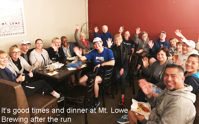
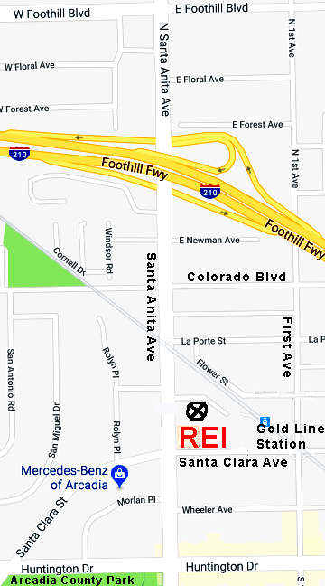
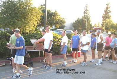 Pizza Tailgate Dinner - held in the REI parking lot or local brewery on the 3rd Wednesdays after the run in the months of April through October. Pizza is provided as a member benefit to club members only, guests and non-members give $10 to the treasurer. If a guest becomes a member during that year, they can deduct the $10 from the $35 membership. Where else can you get 7 pizza nights for $35? Bring your folding chairs, drinks and any additional food items if you dont like pizza.
On meeting nights (2nd Wednesday) during the months of April through September, it is BYO dinner and drinks in the REI parking lot.
Return to: Foothill Flyers Home Page
The domain of this page is Foothillflyers.org
Copyright ©2026 Tom O'Hara. All rights reserved.
Contact: webmaster at foothillflyers dot org
